Image: Red Bull Content Pool
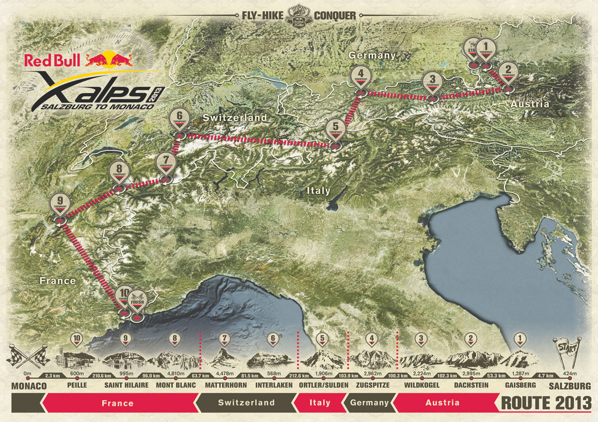
The Red Bull X-Alps 2013 is to be the biggest yet, with organisers announcing that the route is now more than 1,000km long as the crow flies. At 1,031 km long the course is almost 20% – 167km – longer than the 2011 race, which was 864km as the crow flies.
The route was officially unveiled at a launch in Salzburg, Austria on 11 March, where organiser Hannes Arch said the longer route would “test athletes to the limit”. The route is longer because of extra turnpoints. The 2011 race had eight turnpoints plus the start and finish – 2013 will see 10 plus start and finish.
The 2013 race will zig and zag through the Alps. After the start in Salzburg pilots will head south to the Dachstein, before heading west to southern Germany. They will then have to turn sharply south to the Sud Tyrol in Italy, before heading west but staying north to reach Interlaken. From there it’s south to the Matterhorn, west to Mont Blanc, and then even further west out to St Hilaire, home of the famous Coupe Icare.
This adds a whole new dimension to the event – in all previous X-Alps races athletes have made the Mont Blanc turnpoint and then headed south. This year they will instead have to follow the arc of the French Alps all the way round before turning south towards Monaco and goal.
TURNPOINTS
Like 2009 and 2011 the race will begin in Salzburg, Austria. From there athletes must make their way southeast to the Hoher Dachstein (2,995m) and then west through the Hohe Tauern national park to the Kitzbühel Alps where a tough ascent of Wildkogel (2,224m) awaits.
Athletes must then negotiate tricky Innsbruck airspace and a potentially confusing Karwendel crossing to the Zugspitze (2,962m), Germany’s highest mountain. The route then crosses to the southern Alps, passes through Sulden in the Ortler region and then heads west on one of the longest stages to Interlaken in Switzerland. Then it’s south across the Bernese Oberland to the Matterhorn (4,478m), one of the most spectacular parts of the route.
The race then takes in Mont Blanc (4,810m), before heading west to St Hilaire. After that it’s south to Monaco and, for the elite few, splashdown on the raft in the Mediterranean. Athletes who complete the 1,031km 2013 race could well travel over 2,000km by foot and paraglider to get to Monaco, making the 2013 race the hardest yet.
…read more
Source: Cross Country – International Free Flying Magazine
